Hi, I am working with CT images and want to create a binary label map of the landmarks I define using the ‘Annotation’ tool. Is there a way to do that?
Thanks.
Hi, I am working with CT images and want to create a binary label map of the landmarks I define using the ‘Annotation’ tool. Is there a way to do that?
Thanks.
Hi Joelle,
After you define landmarks in the Annotation tab, you can export them as binary mask in the Export tab.
Choose “Label Map” as the Label Encoding type, and specify a radius in mm (which is the size of the blobs that will be written in the label map).
Hi, thanks for your quick reply. I assume you are talking about ImFusion Labels? Is it also possible in Suite?
Well, you did post in the ImFusion Labels section of the forum 
Using Labels is indeed the recommended way to annotate datasets.
There is a more convoluted way to do it from the Suite, but I have just found a potential bug so I’ll fix it before describing the method here.
Dear Raphael, is there an update on this topic? Could you provide some information on how to do it from the Suite.
Or if you can do it from the labels, is it possible to export the landmarks then to Suite workspace to perform some registration evaluation?
Hi Jorge,
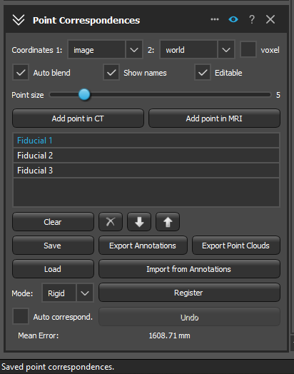
what is it you want to do exactly? For one, you can just add “Label” annotations on any data set. If you have a pair of CT volumes (or any other modality, for that matter), you can use “Registration > Point Correspondences” to define correspondences, save/load them, register them, and compute their errors. They can also be exported/imported to and from annotations (the module will ask upon opening whether any applicable points should be imported). If you want to convert those points further into a labelmap on each volume, we’d have to look into it what the easiest is in the Suite for that (I’m confident there is a way)! Cheers,
Wolfgang
Hi Wolfgang,
Thanks a lot for you reply!!, “Point Correspondences” was exactly what I was looking for, I was for some reason trying to find that by adding normal meshes.
Hello everyone!
An additional question regarding this, where are the exported points stored after clicking save? It seems like they save but I am unable to locate the file with the points to load later. (see image)
It will be saved to two text files “wpoints.txt” and “tpoints.txt” (this is historic, the first letter stands for “world” and “tracked”, but it is for the first and second image, respectively); a third file “corrtexts.txt” will contain the descriptions.
The directory is the folder where the first image data set is located, if this information is available (in the “filename” property of the loaded image) - otherwise the current working directory.
Apart from this admittedly a bit archaic save option, you can also just save a Workspace while the controller is open, it will store all the points in the XML tags.